Здесь нет запутанной карты, сложных головоломок (вообще никаких), хитрых диалогов или фантастических миров. Однако эта игра по достоинству считается шедевром. Победитель конкурсов 2004 IF Art Show в рубрике Landscape и 2004 XYZZY Awards в рубрике Best Setting.
Вся игра "The Fire Tower" - один простой хайк (поход) по реальному фрагменту тропы Appalachian Trail в американском парке Great Smoky Mountains в штате Теннесси. Вот отзыв от Emily Short (гуглоперевод):
Панорамный вид с реальной башни на верхушке горы Cammerer: https://goo.gl/maps/xDuTMUKoZKdh2DSn8
Можно играть онлайн: iplayif.com
А можно скачать и запустить на своём компьютере:
Вся игра "The Fire Tower" - один простой хайк (поход) по реальному фрагменту тропы Appalachian Trail в американском парке Great Smoky Mountains в штате Теннесси. Вот отзыв от Emily Short (гуглоперевод):
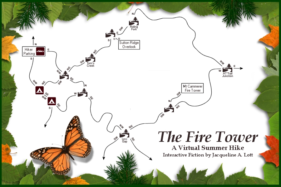
Это отлично. «Firetower» — это великолепный поход через горы Теннесси.Карта маршрута: firetower_map.jpg
Автор упоминает в своих заметках, что это место является одним из ее любимых мест, и это заметно. Обстановка остро проживается и описывается с ответами на все чувства. Это не просто формальные ответы: у меня осталось очень четкое представление о флоре в этой области и несколько более мимолетное представление о фауне. Произведение предвосхищает множество нестандартных действий — особенно меня позабавила реакция на мои попытки повернуть указатели.
«Пожарная башня» также дает сильное ощущение непрерывности пространства и времени. Между локациями есть переходные описания, которые позволяют узнать, как далеко вы прошли, по какой местности и что видели по пути. Когда вы путешествуете далеко, на ваших часах проходит значительное время. Тем временем солнце всходит и садится в небе; меняется качество воздуха; тени удлиняются; отдыхающие просыпаются, активны и ложатся спать. Если вы выйдете из леса достаточно поздно, вы даже услышите укоризну от персонажа, который вас подберет.
Персональный характер тоже хорошо сформирован. Попытки попробовать различные растения, например, или взять вещи, которые вы не должны срывать, встречают характерные "лесничие" ответы — информативные, но с заботой о безопасности и сохранении дикой природы. Суть не просто в том, чтобы проповедовать хорошее поведение в парке: персонаж ощущается как конкретный человек. Она поет про себя Стиви Никс, сначала съедает лучшие кусочки из своего микса и не паникует при встрече с медведем. Ее приятное, приземленное отношение влияет почти на каждый описательный отрывок.
Панорамный вид с реальной башни на верхушке горы Cammerer: https://goo.gl/maps/xDuTMUKoZKdh2DSn8
Можно играть онлайн: iplayif.com
А можно скачать и запустить на своём компьютере:
Примерно так:
$ wget https://ifarchive.org/if-archive/art/if-artshow/year2004/firetower.z8
$ frotz firetower.z8
"You're certain that you'll be okay on your own?" he asks.
You smile at him, tightening the pack around your waist. A slight laugh creeps into your voice - it's not as if you haven't done this before. "Yes, dear. I'll be fine. It's nothing personal, I just..." You take in the concerned expression on his face and your voice softens slightly. "I just need a break. Not from you, necessarily, but from everything: work, responsibilities, friends. I just need a day to myself, you know?"
He nods. "Yeah. Yeah, I guess I do. No worries; I get like that myself sometimes. Just in case something happens, what route do you plan to take? Your usual?"
You nod. "Yeah. I'll head up the long way, on the Lower Mt. Cammerer trail, hit the Appalachian trail to get to the tower, then descend by going further down the AT towards Low Gap. I'll take the Low Gap trail back to the campground."
He smiles at you. "Like I said, 'Your usual.' Listen, I'll be back to pick you up about... Hm, what time?"
"Well, if I were just hiking, I could be out by mid-afternoon, but I really want to take my time and enjoy things. I guess it gets dark about... what? Half past nine these days?" He nods. "I should be out by then. I'll meet you right back here at nine-thirty, okay?" you offer up your most reassuring smile.
"Sure," he says. "I love you. Be careful, and have a great hike."
With that, he kisses you lightly on the lips and gets back in the car. He waves out the driver's side window and heads off toward the north end of the parking lot, towards home. Soon, the car is out of sight entirely.
[Press any key...]
A virtual summer hike
Copyright (c) 2004 by Jacqueline A. Lott
Submitted as a Landscape Entry to the 2004 IF Art Show
For hints and information, type "about."
Enjoy your walk, and thank you for playing.
Release 1 / Serial number 040528 / Inform v6.30 Library 6/10
Standing alone at the edge of the deserted parking lot, you take in a deep breath of fresh air and glance about. An inviting trail beckons from the forest to the east; that path quickly curves among the hemlocks and out of sight. Two roads depart from the parking lot: one leads north, towards home, the other south, toward the campground not quite half a mile distant.
Today's hike is one you've done many times before, and you're intimately familiar with the ground you'll cover. You know without the aid of a map that you can proceed either east or south, and that either route will bring you toward the Lower Mt. Cammerer trail. From there it's a slow and steady climb to the fire tower.
>inventory
You are carrying:
some socks (being worn)
some hiking shorts (being worn)
a shirt (being worn)
some hiking boots (being worn)
a hip pack (being worn and closed)
a watch (being worn)
>look
The hiker parking area is where people generally leave their cars while exploring the nearby trail system in the national park, but this morning it's devoid of vehicles. A grassy hill, recently mown, lines the western edge of the parking lot, while a forest abuts it to the east. From the parking lot there are two roads: one departing north, toward the park exit, and one leading south toward the campground just under half a mile away. A trail enters the woods to the east, quickly disappearing amongst the hemlocks.
For your hike, you can proceed either east or south. Either route will take you to the Lower Mt. Cammerer trail.
>smell
The air smells of life, of greenery and nearby streams. Lovely.
>examine sky
The sky is a rich, warm blue, and the sun is climbing in the east.
>x forest
A forest of towering hemlock hugs the eastern margin of the parking lot, and a trail enters the woods due east.
A slight breeze blows out of the east.
>x watch
You glance down at your watch, a rather chunky and unstylish accoutrement purchased for fifteen dollars at the drugstore. Fashion critiques aside, it's a functional, water-resistant, glow in the dark timepiece.
At present, it indicates that the time is 7:05 AM.
>x pack
You don't know what you'd do without your wonderful hip pack on day hikes like this. It's compact, it's capable of carrying everything you could really need (even in an emergency), it holds a water bottle, and it's your favorite color (green!).
>east
You decide it's best to leave the pavement as quickly as possible, and opt for the trail into the woods. The path, lined with wildflowers, curves south, then southeast, before joining with the Lower Mt. Cammerer trail.
You're standing at the junction of two trails, and two signs are nailed to a single post here to orient you. The Lower Mt. Cammerer trail heads northeast, toward the Sutton Ridge Overlook and, eventually, to the Appalachian Trail. Alternately, the trail continues southwest toward the campground, about two tenths of a mile away. A second trail, unnamed, runs northwest, toward the parking area where you began, or southeast, toward the Low Gap Trail.
A patch of yellow flowers is growing at the base of the signpost.
>look
You're standing at the junction of two trails, one running northwest-southeast, the other running northeast-southwest. At the north corner of the junction, two signs are nailed to a single post indicating where each trail leads.
>smell flowers
Hm... you can't really detect much of a scent from these flowers. Their delicate beauty makes up for the lack of scent.
>listen
Somewhere out of sight, a crow caws.
>touch flowers
You carefully grasp one of the jewelweed stems between your fingers so that you can examine it better, then carefully release it again.
>x signs
There are two signs on the post. The uppermost sign faces southeast, and is oriented so that you know it pertains to the trail that runs northeast-southwest; it reads:
LOWER MOUNT CAMMERER TRAIL
Sutton Ridge Overlook 1.2 >
Appalachian Trail 7.3 >
< Cosby Campground 0.2
The other sign faces southwest and pertains to the access trail from the parking lot, which has no name; the sign reads:
Low Gap Trail 0.4 ->
<- Hiker Parking 0.4
An insect lights upon your ear, but a wave of your hand sends it away.
>rotate signs
Ooh. Aren't you evil. No. That would get people lost in the wilderness and then they might die and you could never live with that horrible, terrible, burning guilt.
>_ (и так далее)

no subject
Date: 2023-08-10 09:51 (UTC)no subject
Date: 2023-08-15 07:19 (UTC)